Storms With No Names
Jay TItlow, WeatherFlow Networks Meteorologist
Two storm systems pummeled the Southeast New England and much of the US West Coast over the last week, behaving more like Tropical systems than more typical low-pressure systems. Precipitation totals over ten inches in the hills around the Bay area easily broke records, while winds throughout the region made for a blustery Sunday, with wind speeds of 50 MPH or more for much of the day.
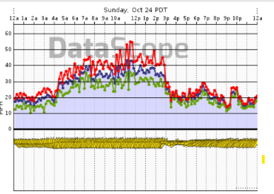
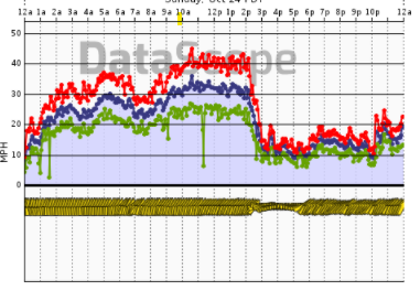
(wind graphs from area WFn Holdings, Inc. (WeatherFlow Networks) ProNet sites: Left Graph-Blunt Point, Right Graph-San Pablo Bay)
Meanwhile, in Southeast Massachusetts wind speeds topped 100 mph in an early season Nor’easter. Tempest Weather System sites along with WeatherFlow Network’s marine observing network comprised of ProNet observation sites performed admirably, revealing a resultant depiction of rather nasty surface wind fields.
As expected, the winds over water provided monster values (such as San Pablo Bay, where seven hours of wind gusts > 40 mph whipped across the region), and Tempest sites were able to fill gaps where no observations were present in previous events. Most analysis schemes would fail to generate wind speeds to the magnitude even these consumer Tempest stations reported during these two storms.
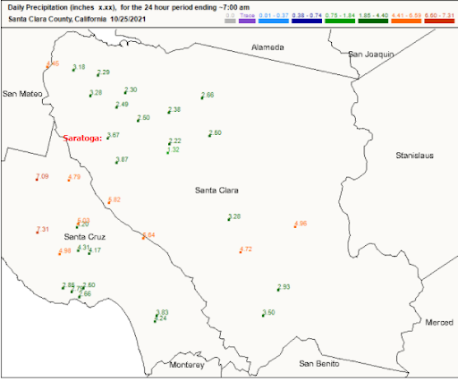
That being said, the following data makes these events two for the record books. Community Collaborative Rain, Hail and Snow Network (CoCoRaHS) is a remarkable grassroots effort that is now a component of the National Weather Service’s effort to accurately depict rainfall event totals, using citizen weather observations. The map depicting 24-hour totals indicates impressive values across the region with multiple estimates greater than seven inches in the Santa Cruz Mountains! This is a big number from most, if not all, precipitation estimates, and a number often used to define impressive snow events. If ones utilizes to 10:1 ratio (1 inch of rain equals 10 inches of snow), yields over 70 inches if it was all snow. (This, by-the-way, would have been the preferred method to receive this much precipitation in such a short period of time.) Result: White water rafting was sport of choice for much of the region by Sunday afternoon and into Monday!
Meanwhile, back east, the following table depicts just how valuable WeatherFlow Networks’ ProNet is for reporting the severity of the brutal wind field that spent quite a while over the region. This storm produced an intense wind field with over 20 sites clocking hurricane force gusts at least one sites that had a gust greater than 100 MPH gusts!
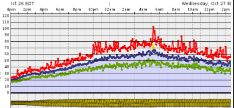
Peak wind gusts from NE Nor-easter Oct 26-27th
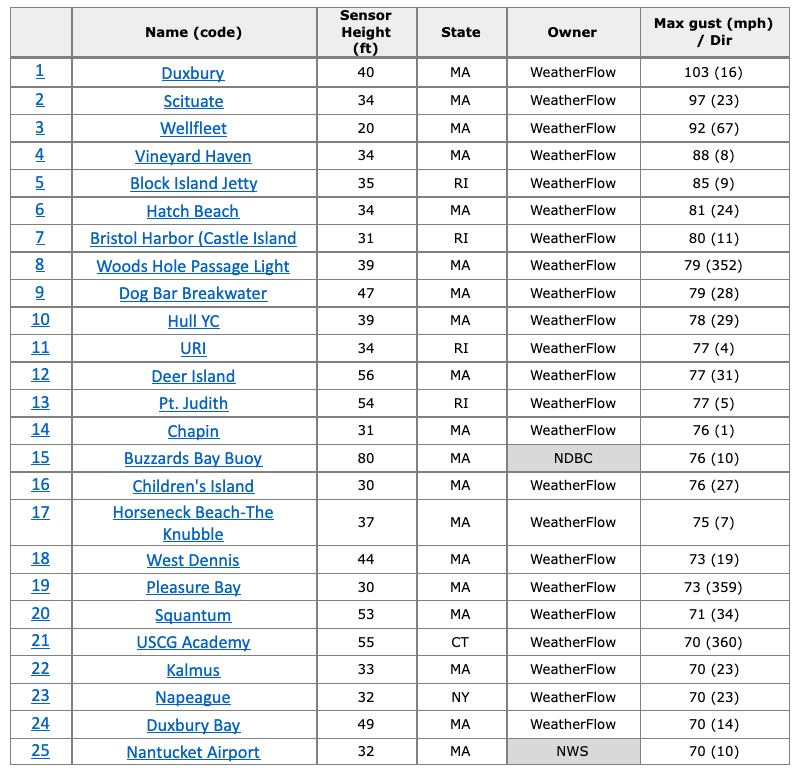
The data tells an amazing story; A whopping 23 of the top 25 wind speed gusts captured by marine weather observations came from WeatherFlow Networks’ ProNet stations. It is this robust reliability that has made WeatherFlow Networks and WeatherFlow-Tempest trusted names in both the commercial and consumer weather industries.
____________________________________
More about the WFn Holdings, Inc and WeatherFlow-Tempest Partnership:
WFn Holdings, Inc (WeatherFlow Networks) owns and operates the largest industrial grade private weather observing network in the world, and supplies affiliate company WeatherFlow-Tempest with exclusive data. WeatherFlow Networks also directly serves specialized weather data users such as NOAA and the Hurricane Insurance Industry.