Tornado –
Murrels Inlet , SC
 Weatherflow leverages many advanced algorithms to determine where to deploy observing assets. An ideal observation asset will have the following characteristics:
- A location that is visited often, either by a single client, or a wide variety of clients, or is of critical strategic importance to national security (e.g. Boston Police Department Mesonet).
- The site must deviate meteorologically from its surroundings (e.g. common sea breeze area). What would the wind be doing if there was no observation there? Weatherflow wants to place sites right where that question is most difficult to answer.
Murrell’s Inlet, South Carolina, was an excellent choice as it is adjacent to a very popular nautical destination. Tourism, including water sports, are among the many non-direct reasons for the site location. Meteorologically, the South Carolina coast is one of the more active stretches of the Atlantic coastline for sea breezes. A healthy 20-knot breeze is not uncommon on a spring or summer afternoon with a National Weather Service (NWS) forecast that needs an upward bump on the breeziest afternoons.
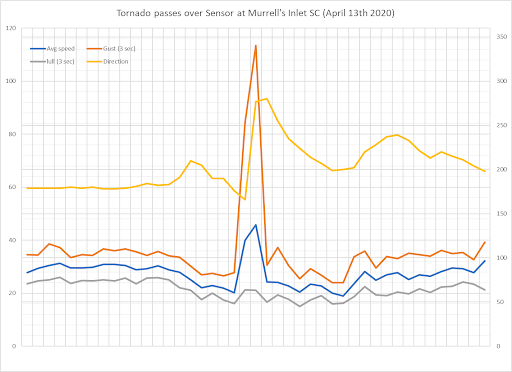
While it is a prime location for sea breezes, in early 2020 Murrell’s Inlet found itself in the crosshairs of nature’s most ephemeral and dangerous weather events – a tornado. As a line of severe storms rolled through the Carolinas on April 13, 2020, several tornadoes formed. The National Weather Service confirmed that one tornado likely traveled along the beach at Huntington State Park before moving offshore, where it passed by near the WeatherFlow HurrNet station at Murrel’s Inlet. That station recorded a wind gust of 114 mph (EF-2 waterspout).