Hurricane Zeta Water Levels
Weatherflow’s reputation in monitoring winds is second to none. Over the last few years there has been a lot of interest in the 1- 2 punch of damage in coastal areas of wind and storm surge. Everybody wants to know the origin of damage…”did my house get damaged because of wind or storm surge”? Well, WeatherFlow thought, we already capture coastal winds, and wind ends up a significant contributor to the magnitude of storm surge, so why not measure both wind and water level.
We were fortunate enough to undertake a project to measure water levels at Bayou Bienvenue in Louisiana… and the results have been impressive.
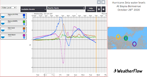
Putting the Hurricane gate down allowed for the water level (surge) associated with the tropical storm to remain east of town! The strong easterly flow pushed water high on the outer gate sensors (blue line), while just on the other side of the gate, levels remained several feet lower (green line). Man 1, Mother Nature 0! That WeatherFlow was able to capture this win helps emergency managers and urban planners prepare for future marine inundation events and could save lives.