Hurricane Winds
Weather events: High winds in Tropical Cyclones – eyewall passages, tornadoes, and storm damage (oh my!)
Weatherflow skill sets: (Met knowledge, engineering)
One of the most elusive aspects of the destructive force of a Hurricane is the tornadic activity associated with these systems. Often the most violent aspects of tropical systems (spin-downs in the vicinity of spiral bands), Weatherflow has observed these events on dozens of occasions. As hurricanes move, it is the right front quadrant where most of the action takes place. Some tropical systems storms seem to have a propensity to produce impressive numbers of tornadoes. For example, Hurricane Irma produced over 20 confirmed tornadoes in the vicinity of Melbourne Beach over 2 Orlando, over 100 miles away from the center which was around Tampa.
NJ Coast – Two of the most recent examples of spin down tornadoes along the coast of New Jersey were at Beach Haven Ludlam Bay. Both tornadoes occurred a good distance from the center of the parent tropical cyclone and it’s very helpful for Weather Service staff to have stations that can capture these events because they’re rather hard to digest. Determining whether spin down tornadoes in tropical cyclones occurred has often been delegated to post storm inspections by Weather Service employees. They determine whether there is a cyclonic spin to tree damage and debris fields and that is useful data for weather and climate research. It would be much more advantageous, however, if we could determine whether these are tornadoes while they’re happening so we can recommend the appropriate actions to be taken by our end- users. In this case, NWS was able to track tornadoes in real time, as the following notice shows:
Tropical-storm-force winds extend outward up to 160 miles (260 km)from the center. During the past couple of hours, a wind gust to 78 mph (126 km/h) was measured by a WeatherFlow site in Ludlam Bay, New Jersey, while a wind gust to 71 mph was observed in Beach Haven, New Jersey. These two wind reports appear to have been associated with nearby tornadoes.
The due diligence that WeatherFlow employs with over 20 years in the business is what makes their “Event capture rate” far above others who have tried. WeatherFlow has always prided itself in going the extra mile with hardening techniques that increase survivability to near 100% for its observation sites. In fact, a subset of WxFlow’s professional network called HurrNet was designed explicitly to withstand up to Category 3, guaranteed, and, to date, has not had a failure in over a dozen Hurricanes, and an additional 20 tropical storms.
WeatherFlow has set the standard for reliability in data collection. Just to drive this point home, what follows is a small sample of other extreme events we captured, despite skeptical claims that the full fury of a tornado cannot be observed because it is too small and the peak winds in a hurricane can’t be tracked because they’re too intense for too long.
Superstorm Sandy – Weatherflow measured the strongest wind anywhere in the storms’ landfalling area, a whopping 115 MPH gust at Great Gull Island in eastern LI Sound.
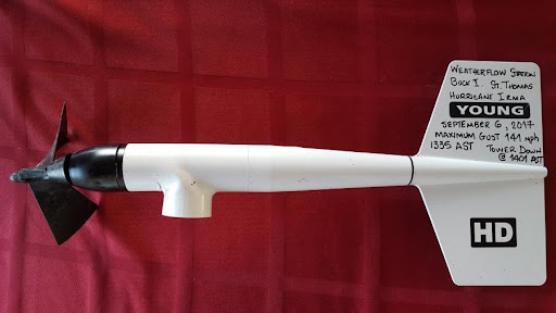
Hurricane Irma- Measured a 141 mph gust at Buck Island, just south of the Charlotte Amalie Harbor, USVI. Of note, the cement-based lattice coast guard tower, where Weatherflow equipment was mounted, blew over not long after the observation of peak gust occurred. The photo on the right is the instrument that recorded the 141 value after in was removed from the tower. It was actually still recording data!
Hurricane Maria – Numerous observations of wind gusts over 100 mph, including Gurabo (several miles inland), PR and Las Mareas, PR where a 124 mph was observed on the field data-logger and retrieved when cell service was restored almost 2 months after the event! Weatherflow site Cabrolita observed gusts over 130 mph only 2 weeks apart as the Irma/Maria 1-2 punch give the small uninhabited island quite a whipping.
Hurricane Harvey – By many standards, the snottiest of the big three storms of 2017 but it did bring a successful initial partnership deployment between Weatherflow and Dr. Forrest Masters and the Folks at University of Florida (UF), as the groups combined assets to get additional data via mobile observations (weatherflow equipment mounted on a UF portable tower).
Hurricane Ike – All WeatherFlow assets in the Houston/Galveston region survived in an initial test of a new system with a peak gust of 110 mph observed at Crab Lake. NWS had estimated a top speed of 111 mph via dropsonde, so an “attaboy” to both groups for utilizing two methods to arrive at two numbers only 1 mph apart!