Hurricane Laura
WFn Hodlings, Inc. (WeatherFlow Networks) tracked and reported critical weather observations in real-time as Hurricane Laura came ashore in Louisiana on August 27, 2020. Newly released data and images show the extreme winds and enduring power of the storm, as the category 4 hurricane maintained its strength while advancing inland.
WeatherFlow’s data was shared with NOAA (the National Oceanic and Atmospheric Administration) during the event. With all storms the company provides extensive observational data to relevant government agencies in order to better inform storm warnings, advisories, and emergency relief efforts.
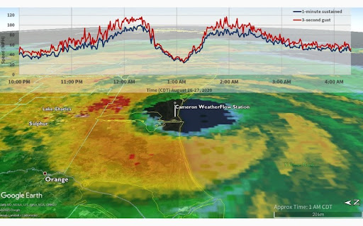
Hurricane Laura made landfall at 1 a.m. CDT on August 27th, 2020 with the storm’s eye passing directly over WeatherFlow’s Hurricane Network station in Cameron, located on the southwestern coast of Louisiana. Cameron was the first weather station to report hurricane-force winds, with 101 mph maximum sustained winds and a 117 mph gust.
Thirty miles inland from Cameron, near Lake Charles, rugged mobile weather stations were deployed as part of WeatherFlow’s partnership with the University of Florida’s Coastal Monitoring Program. As Laura traveled inland, these stations were placed in the storm’s path and captured its unusual endurance.
“The data reported by our inland mobile stations was especially interesting,” explained WeatherFlow Lead Meteorologist, Dr. Marty Bell. “They provided the first indication that, rather than weakening rapidly after landfall, as most hurricanes do, Hurricane Laura maintained its
intensity for a considerable distance, with maximum sustained winds of 104 mph and a 132 mph gust reported some 30 miles from the coast.” The NOAA station at Lake Charles airport recorded similar wind speeds before it failed as a result of the storm. Read More>>>